
43rd International Conference,Workshop and AGM
Conference Theme: “Intelligence Geospatial Mapping for Managing Elections, Census and National Security”Background Info: The Nigerian Cartographic Association (NCA) was established in 1978 as the officially recognized professional body of all map makers and GIS data visualisation professionals in Nigeria. As part of her professional activities, the NCA organizes Annual Conferences, Workshops and AGM that bring together experts, scientists, researchers, academicians and general practitioners (individuals and corporate) from all over the country (and beyond) to present, exhibit and discuss new developments and innovations in mapping sciences and technologies with focus on Cartography, GIS, Remote Sensing and Geoinformatics applications for Good Governance, Security and National Development. The 43rd Conference activities will include the Induction of new members, prize giving as well as Fellowship, Merit/Honourary Awards to members, individuals/corporate bodies.
Call For Papers NCA is interested in strategic approaches to bridging the knowledge gaps in Cartography, GIS and Remote Sensing applications for national development. Well written abstract of between 250 & 300 words and well-researched and referenced articles are requested for presentations. The long version of accepted manuscript must not be more than 15 pages double spaced, Times New Roman, Pica 12 font size. Table(s) should be labeled at the top e.g., “Table 1. Polling booths in AMAC, Abuja”, while Figure(s) should be labeled below e.g., “Figure 2. 3D Mapping of Urban Crimes”, etc. We strongly lay emphases on good MAP(s) with proper embellishments having clarity, orientation, balance and good use of visual variables. There should be no abuse of colours. Manuscripts should be prepared with MS-Word, using APA 6th Edition for referencing. Title: font size 13, sections and subsections: font size 12-bold and first letter caps. Author(s) name(s): First name-initial-surname, use 1, 2, etc. for affiliations and * for correspondence author. Only manuscripts properly formatted will be accepted, please take note and comply. ARTICLE(S) should be sumitted TO: The Editor, The Nigerian Journal of Cartography & GIS: ncacargisjournal@gmail.com, copy nigeriancartographers@gmail.com. Paper handling charges for non-registered members is N5,000; ($10) , Account: Nigerian Cartographic Association, UBA Account: 1001020644. NOTE: Accepted paper for publication will be charged separately. Paper Submission Guideline Title (centralized – Font 14); Author(s) & Affiliation(s) (centralized –Font 12), Abstract & 5 key words (indent left – Font 10) 1. Introduction 2. Materials and Method 3. Results and Discussion 4. Conclusion & Recommendation References (APA). NOTE: All subsections must be font Size 12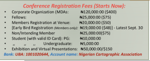 Conference Registration Fees (Starts Now):
Corporate Organization (MDAs: N120,000:00 ($400)
Fellows:
N25,000:00 ($75)
Members Registration at Venue: N20,000:00 ($50)
[Early Bird Registration (Members only): N19,000:00 ($48)] - Latest Sept. 30
Non/Intending Member N25,000:00($75)
Student (with valid ID Card): PG: N10,000:00
,, ,, ,, Undergraduate: N5,000:00
Exhibition and Virtual Presentations: N50,000:00/$150
Bank: UBA: 1001020644, Account name: Nigerian Cartographic Association
Sub-Themes:
1. Intelligence & National Security
Crime/Banditary Mapping and Hotspots Assessment
Maps in Community Policing and Security
Maps in Boundary Assessment and Conflict Resolution
Mapping Inter-tribal/Religious Conflicts and National Cohesion
Mapping Insurgencies and Political Unrests
SDI and National Geoinformation Security
Military Intelligence in National Security
2. Elections and Population Census Mgt.
GIS in Election Monitoring and Management
Enumeration Area Demarcation and Mapping
Polling Booth Location Mapping and Database Creation
Synchronized Geo-portal for Census/Electioneering
Population Growth and Resource Diversification
Population, Sanitation, Drug use and Risk Assessment
Population Governance and Resource Allocation
Tourism, Social Security and Raison Detre
Public Safety: Health, Emergencies and Disease Mapping
3. Geospatial Mapping Technologies
(GNSS, UAV, Survey, Web Mapping, Neo-Cartography, GIS, Remote Sensing,
Cartography, Mobile Mapping, Land/Engineering survey, etc.):
Maps in E-governance and LGA Administration
Use of Maps for Urban and Regional Planning/Infrastructure
Maps in Traffic Monitoring and Management, Road Alignments
Mapping Oil Exploration, Exploitation and Spill
3D Map Models, Animation and Smart City Visualisation
Maps in Resource Exploitation: Precision Agriculture, Mining.
Maps in Transportation and Telecommunications
Map in Environmental Management
Mapping Land Degradation: Erosion, Flooding, Deforestations, etc.
Maps in Environmental Impact Assessments
4. Cartographic Education/Practices in Nigeria
Professionalism and Manpower in Cartography
Cartography and Geospatial Intelligence in Nigeria
Cartographers In National Security in Nigeria
Cartographers in Census Mappping
Institutionalization of Cartographeric Practices
Conference Registration Fees (Starts Now):
Corporate Organization (MDAs: N120,000:00 ($400)
Fellows:
N25,000:00 ($75)
Members Registration at Venue: N20,000:00 ($50)
[Early Bird Registration (Members only): N19,000:00 ($48)] - Latest Sept. 30
Non/Intending Member N25,000:00($75)
Student (with valid ID Card): PG: N10,000:00
,, ,, ,, Undergraduate: N5,000:00
Exhibition and Virtual Presentations: N50,000:00/$150
Bank: UBA: 1001020644, Account name: Nigerian Cartographic Association
Sub-Themes:
1. Intelligence & National Security
Crime/Banditary Mapping and Hotspots Assessment
Maps in Community Policing and Security
Maps in Boundary Assessment and Conflict Resolution
Mapping Inter-tribal/Religious Conflicts and National Cohesion
Mapping Insurgencies and Political Unrests
SDI and National Geoinformation Security
Military Intelligence in National Security
2. Elections and Population Census Mgt.
GIS in Election Monitoring and Management
Enumeration Area Demarcation and Mapping
Polling Booth Location Mapping and Database Creation
Synchronized Geo-portal for Census/Electioneering
Population Growth and Resource Diversification
Population, Sanitation, Drug use and Risk Assessment
Population Governance and Resource Allocation
Tourism, Social Security and Raison Detre
Public Safety: Health, Emergencies and Disease Mapping
3. Geospatial Mapping Technologies
(GNSS, UAV, Survey, Web Mapping, Neo-Cartography, GIS, Remote Sensing,
Cartography, Mobile Mapping, Land/Engineering survey, etc.):
Maps in E-governance and LGA Administration
Use of Maps for Urban and Regional Planning/Infrastructure
Maps in Traffic Monitoring and Management, Road Alignments
Mapping Oil Exploration, Exploitation and Spill
3D Map Models, Animation and Smart City Visualisation
Maps in Resource Exploitation: Precision Agriculture, Mining.
Maps in Transportation and Telecommunications
Map in Environmental Management
Mapping Land Degradation: Erosion, Flooding, Deforestations, etc.
Maps in Environmental Impact Assessments
4. Cartographic Education/Practices in Nigeria
Professionalism and Manpower in Cartography
Cartography and Geospatial Intelligence in Nigeria
Cartographers In National Security in Nigeria
Cartographers in Census Mappping
Institutionalization of Cartographeric Practices