Professional Excellence
Promoting high standards in Cartography, GIS and related geospatial professions.
Advancing Cartography, GIS, Remote Sensing and geospatial technologies through professional practice, research, training and national development.
GEO-AI MAP DATA FOR SECURITY, ELECTIONEERING AND HEALTH MANAGEMENT
14–18 September 2026
📍 Kaduna, Nigeria
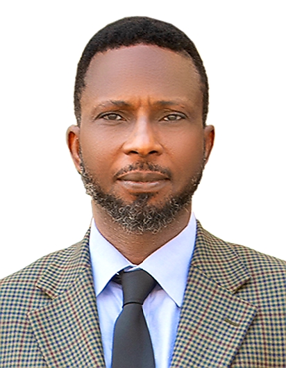
“It is with profound joy, gratitude and a deep sense of responsibility that I warmly welcome you all to the 47th International Conference, Workshop and Annual General Meeting (AGM) of the Nigerian Cartographic Association.”
On behalf of the National Executive Council, Fellows, Members and the entire Nigerian Cartographic Association, I sincerely appreciate your presence at this important gathering. Your attendance demonstrates your commitment to the advancement of cartography, geoinformatics, geospatial science, earth observation, artificial intelligence and their application to national development.
This year's theme, “GEO-AI MAP DATA FOR SECURITY, ELECTIONEERING AND HEALTH MANAGEMENT,” is timely, strategic and highly relevant to Nigeria and the global community. It highlights the growing importance of combining geospatial intelligence and artificial intelligence to support better decisions in security, democratic processes, healthcare and national development.
WELCOME ADDRESS BY ASSOC. PROF INNOCENT EHI BELLO, FNCA, THE NATIONAL PRESIDENT, NCA
TO THE 47TH INTERNATIONAL CONFERENCE, WORKSHOP, AND ANNUAL GENERAL MEETING (AGM) OF THE NIGERIAN CARTOGRAPHIC ASSOCIATION (NCA)
Theme: “GEO-AI MAP DATA FOR SECURITY, ELECTIONEERING AND HEALTH MANAGEMENT”
Special Guests of Honour, Captains of Industry, Heads of Ministries, Departments and Agencies (MDAs), our Royal Fathers, Heads and Representatives of Security Formations, Distinguished Members of the Media, Corporate Members, Fellows and Members of the Nigerian Cartographic Association, our dear students, distinguished scholars and professionals, invited guests, ladies and gentlemen.
It is with profound joy, gratitude and a deep sense of responsibility that I warmly welcome you all to the 47th International Conference, Workshop and Annual General Meeting (AGM) of the Nigerian Cartographic Association (NCA).
On behalf of the National Executive Council, Fellows, Members and the entire Nigerian Cartographic Association, I sincerely appreciate your presence at this very important gathering. Your attendance demonstrates your commitment to the advancement of cartography, geoinformatics, geospatial science, earth observation, artificial intelligence and their application to national development.
I particularly welcome our Special Guests of Honour, Royal Fathers, Captains of Industry, Heads of MDAs, Security Agencies, Development Partners, Corporate Organisations, members of the academia, professional bodies, the media and our students. Your presence gives this conference greater significance and reinforces the importance of partnerships in harnessing geospatial knowledge for the benefit of our society.
Distinguished guests, the theme of this year's conference is timely, strategic and highly relevant to Nigeria and the global community.
We are living in an era where location intelligence, artificial intelligence, satellite technology, Geographic Information Systems (GIS), remote sensing, digital mapping, spatial databases and real-time geospatial analytics are fundamentally changing how governments, institutions, businesses and communities understand and respond to complex challenges.
The convergence of Geospatial Technology and Artificial Intelligence — GEO-AI — presents enormous opportunities for Nigeria.
Maps are no longer merely representations of geographical features. Modern maps have become dynamic decision-support instruments, capable of integrating satellite imagery, demographic information, infrastructure, environmental data, mobility patterns, socioeconomic indicators and real-time observations to support evidence-based decisions.
In the area of security, GEO-AI can significantly strengthen our capacity to understand and respond to security threats.
Through the integration of satellite imagery, GIS, artificial intelligence, unmanned aerial systems, geospatial intelligence and spatial analytics, security agencies can improve border surveillance, critical infrastructure protection, crime mapping, early warning systems, emergency response, conflict monitoring and strategic planning.
The Nigerian Cartographic Association therefore recognises the need for stronger collaboration between geospatial professionals, security formations, government agencies, academia and the private sector to ensure that geospatial intelligence contributes meaningfully to a safer Nigeria.
In electioneering, accurate and authoritative geospatial data is equally indispensable.
From delineation and analysis of electoral constituencies and polling units to accessibility mapping, voter distribution, election logistics, monitoring and post-election analysis, geospatial technologies can enhance the efficiency, transparency and credibility of electoral processes.
GEO-AI can support election managers and stakeholders by providing better understanding of where people live, how communities are connected, where polling facilities are located, accessibility challenges, population distribution and logistical requirements.
However, as professionals, we must also emphasise the principles of accuracy, neutrality, privacy, responsible data governance and ethical application of artificial intelligence. Technology must strengthen public confidence and democratic institutions rather than undermine them.
The third pillar of our theme — health management — is equally critical.
Healthcare is inherently spatial. Disease occurrence, health facilities, population distribution, environmental conditions, transportation networks and access to healthcare services all have geographical dimensions.
GEO-AI can help identify disease hotspots, assess healthcare accessibility, optimise the location of health facilities, monitor environmental health risks, support emergency medical response and provide decision-makers with timely spatial intelligence.
The future of public health management will increasingly depend on our ability to integrate people, places, health information and environmental conditions into intelligent geospatial platforms.
As the professional body representing cartographers and allied geospatial professionals in Nigeria, the Nigerian Cartographic Association has a critical responsibility to remain at the forefront of these technological transformations.
Our responsibility extends beyond producing maps. We must contribute to the development of national geospatial infrastructure, professional standards, spatial data governance, geospatial education, research, innovation and capacity development.
We must prepare the next generation of professionals to operate confidently at the intersection of Cartography, GIS, Remote Sensing, Artificial Intelligence, Big Data, Earth Observation, Geospatial Intelligence and emerging digital technologies.
This conference therefore provides an important platform for us to exchange knowledge, share research findings, showcase innovations, build professional networks and develop practical solutions to Nigeria's pressing challenges.
Distinguished ladies and gentlemen, the challenges confronting our nation cannot be solved by one profession, institution or sector alone.
We need stronger partnerships among government, academia, industry, security agencies, professional bodies, technology companies, development organisations and communities.
I therefore call on all stakeholders represented here to see this conference not simply as an academic gathering, but as a platform for collaboration, innovation and national transformation.
Let us move from conversations to practical partnerships.
Let us transform research into policy.
Let us transform data into intelligence.
Let us transform maps into actionable decisions.
And let us transform technological innovation into measurable improvements in the lives of Nigerians.
I wish to specially welcome our students and young professionals.
You are not merely the future of cartography; you are already part of its present and its transformation.
The emergence of Artificial Intelligence, machine learning, cloud computing, digital twins, autonomous mapping, satellite constellations and geospatial big data is creating opportunities that previous generations could not have imagined.
I encourage you to learn continuously, embrace innovation, uphold professional ethics and position yourselves to become global leaders in geospatial science and technology.
At this juncture, I sincerely appreciate the Local Organising Committee, the National Executive Council, our conference partners, sponsors, exhibitors, speakers, facilitators, institutions and individuals who have contributed to the successful organisation of this conference.
I also acknowledge our Royal Fathers, distinguished guests, security agencies, the media and all our corporate and institutional partners for their continued support of the Nigerian Cartographic Association.
To our Fellows and Members who have traveled from different parts of Nigeria and beyond, your commitment to the Association is deeply appreciated.
Distinguished guests, as we commence this 47th International Conference, Workshop and Annual General Meeting, I urge us to engage with open minds, challenge existing paradigms and develop innovative ideas that can be translated into real solutions.
Let this conference mark another significant milestone in the advancement of cartography and geospatial science in Nigeria.
Let us collectively build a future where accurate geospatial information, artificial intelligence and responsible innovation support a more secure nation, a more transparent democratic process and a healthier society.
Once again, on behalf of the National Executive Council of the Nigerian Cartographic Association, I warmly welcome you all to the 47th International Conference, Workshop and Annual General Meeting of the Nigerian Cartographic Association.
I wish us fruitful deliberations, productive engagements, new partnerships, and a memorable conference.
Long live the Nigerian Cartographic Association!
Long live the geospatial profession!
Long live the Federal Republic of Nigeria!
Thank you, and God bless you all.
Assoc. Prof. Innocent Ehi Bello, FNCA
National President
Nigerian Cartographic Association (NCA)
The Nigerian Cartographic Association (NCA) is the officially recognised professional body of map makers and GIS data visualisation professionals in Nigeria.
Founded in 1978, NCA provides a platform for individuals and organisations interested in the study, production and use of maps and related technologies. It is a non-profit professional organisation committed to advancing the profession and its contribution to national development.
Read about NCA →Promoting modern skills, knowledge and opportunities through enhanced cartographic training, professional practice and career development.
Promoting high standards in Cartography, GIS and related geospatial professions.
Encouraging research, modern mapping technologies, publications and technical dialogue.
Supporting geospatial information for governance, planning, security and development.
For full-time students pursuing careers related to the profession.
₦5,000For practising professionals in Cartography and related fields.
₦15,000For recent graduates and practising Cartographic Technicians.
₦15,000For allied professionals and people with relevant technological experience.
₦15,000For institutions, companies and organisations supporting the profession.
₦20,000Join cartographers, GIS professionals, researchers, academics, students and industry practitioners at the 47th NCA International Conference.
NCA's objectives span education, professional practice, research, conferences, publications, mapping programmes and collaboration.
Stay informed about NCA's annual professional gathering and calls for papers.
Explore →GALLERYExplore photographs from conferences, engagements and association activities.
View gallery →MAP COMPETITIONDiscover NCA's mapping competition and opportunities for geospatial talent.
Learn more →National Secretariat
Nigerian Cartographic Association (NCA)
2nd Floor, Data Bank Building, NASRDA, PMB 437, FCT-Abuja
+234 803 736 9829
support@nca.ng